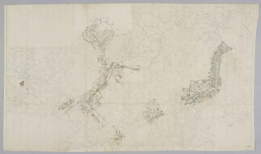
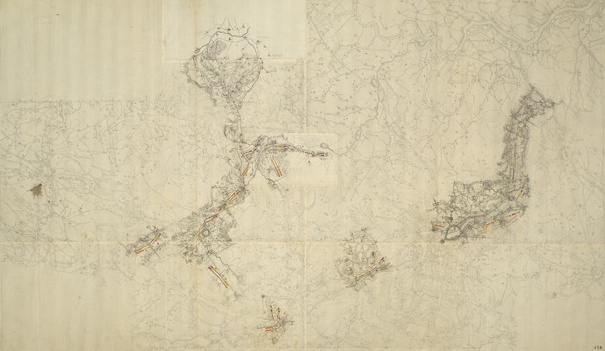
Map of the Netherlands, c.1745 1745 or later
Pencil, pen and ink and watercolour on six pieces of paper, joined | Scale: not stated. 1:110,000 approx. (scale) | RCIN 729062

-
A trace of Fricx's map of Brabant with details of the encampments of the Allied army around Brussels, 1745. War of the Austrian Succession (1740-48). Oriented with north to top.
A useful shortcut for the military mapmaker, faced with the necessity of making extensive surveys, was to take an existing printed map and trace off the major features such as roads, rivers and settlements. The tracing would then be taken into the field where simple observation techniques would be used to add to it more detailed information. This tracing was taken from Crepy's 1740s reprint of Fricx's 1706 map of Brabant (see RCIN 729061.a) and shows the wealth of additional detail which was added to the military map. Parts of this map were enlarged to produce the map of the Brussels canal (RCIN 729136).
Condition: two folds; several other fold lines; ink stains.Provenance
Probably from the collection of military and naval maps and prints formed by Prince William Augustus, Duke of Cumberland (1721-65), third son of George II; subsequently acquired by George III (1738-1820)
-
Medium and techniques
Pencil, pen and ink and watercolour on six pieces of paper, joined
Measurements
Scale: not stated. 1:110,000 approx. (scale)
52.0 x 90.4 cm (image and sheet) (image)
Markings
watermark: Horn in shield, crown above, a ‘4’ suspending the letters L V G below
annotation: Old heading: Encampments in the Netherlands 1745. Other annotations: (Recto) none. (Verso) [top, left of centre, black pencil, cropped, underlined, a number?]; [top, right of centre, black pencil, erased:] Netherlands + Theatre; [bottom, below old heading, black pencil, erased, cropped:] X/.
Alternative title(s)
No title
Netherlands A drawn Plan of part of the Netherlands, with the Encampments of the Allied Army in 1745; [in red ink:] by M.r Schultz.
 after Sebastian Bauman (fl. 1776–83), The Battle of Yorktown (October 1781), 1782. Engraving with some hand colouring, 65.5 x 45.9 cm. RCIN 734069")