Map of the Battle of Glen Shiel, 1719 (Glen Shiel, Highland Region, Scotland, UK) 57°10ʹ12ʺN 05°21ʹ00ʺE) 1719 or later
Pencil, pen, ink and watercolour on paper laid down on coarse linen | Scale: 1:2,600 approx. (scale) | RCIN 727016

John Henry Bastide (active 1711-d. 1770)
Map of the Battle of Glen Shiel, 1719 (Glen Shiel, Highland Region, Scotland, UK) 57°10ʹ12ʺN 05°21ʹ00ʺE) 1719 or later

-
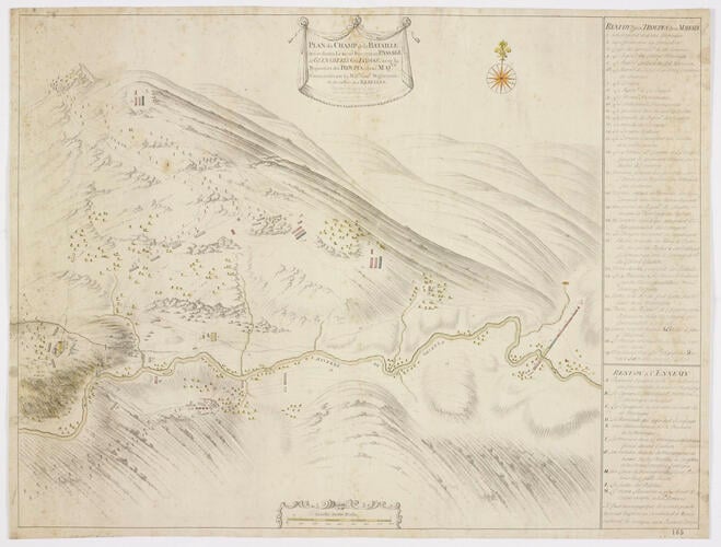
A map of the Battle of Glen Shiel, fought on 10 June 1719 between the British government forces, commanded by Major-General Joseph Wightman (d.1722), Commander-in-Chief in Scotland and the Highlanders and their Spanish allies, commanded by William Murray (1689-1746), Marquess of Tullibardine, resulting in victory for the government army. Jacobite Uprising (1719). Oriented with north to top (compass rose).
In drawing the terrain of the Scottish highlands, Bastide has employed a technique which embodies a transition, on the image, from planimetric depiction, used for the detail on the valley floor, to perspective topographical view for the uplands. This was common practice at this time and the technique was used in earlier centuries. The sweeping brush strokes depicting the vertiginous slopes of the mountains are the forerunner of the same technique employed by Paul Sandby for the Military Survey of Scotland (1747-55). Little figures of soldiers bring the mountainside and the action to life, and, in the valley, the diminutive figure of General Wightman, on horseback, issues his orders for the action. In front of him, and to his left, are the mortar batteries which he used to good effect in defeating the rebels.
Another copy of this map, also by Bastide, entitled ‘A Plan of the Field of Battle that was fought on the 10th of Iune 1719 at the Pass of Glenshiells in Kintail North Britain with ye Disposition of his Majty’s [sic] Forces under ye Command of Majr. Genl. Wightman, & those of ye Rebels’ is in the British Library: Add MS 61343 G, Vol.CCXLIII G. of the Blenheim Papers. When this example of the map was in the then Duke of Marlborough's possession, it was studied and used in analysis of the battle, by A.H. Millar, in a paper entitled ‘The Battle of Glenshiel, 10th June 1719. Note upon an unpublished document in the possession of His Grace the Duke of Marlborough.’ In ‘Proceedings of the Society of Antiquaries of Scotland’ 11 December 1882, pp. 57-69. The manuscript map was redrawn for the purposes of illustrating the paper.
A further two copies of this map, also in English and also by Bastide, are in the National Library of Scotland MS.1648 Z.03/22a and 22b. These examples were formerly in the map collection of the Board of Ordnance in the Tower Drawing Room at the Tower of London where the first example was classified as B.5.F.44. [i.e. Book 5, folio 44]. The entry for this map is item 5 on the list on p.16 of the Register of Draughts (TNA WO 55/2281) as a flat map in Bo.5 Fo. 44 under the entries for the ‘3.d [military] DIVISION. NORTH BRITAIN’.
Additional text: [right, down right side of map in rectangular panel, a key, 1-29, to the positions of named regiments, the first British attack with grenade mortars, further troop emplacements, the location of General Wightman when giving orders during the action:] RENVOY aux TROUPES de sa MAJESTÉ [another key, below the first, A-I, M, to the positions of the Spanish and Highland troops:] RENVOY a l’ENNEMY.
For further reading, see:
M.G.H. Pittock, ‘Murray, William, styled second duke of Atholl and marquess of Tullibardine (1689–1746)’, Oxford Dictionary of National Biography, 2004; online edn, May 2006.
J. Falkner, ‘Wightman, Joseph (d. 1722)’, Oxford Dictionary of National Biography, 2004; online edn, Jan 2008.
Condition: one fold line; surface dirt, especially along right edge; a long tear, left, was repaired by laying the map down on linen. Verso: foxing.Provenance
Probably from the collection of military and naval maps and prints formed by Prince William Augustus, Duke of Cumberland (1721-65), third son of George II; subsequently acquired by George III (1738-1820)
-
Creator(s)
Acquirer(s)
-
Medium and techniques
Pencil, pen, ink and watercolour on paper laid down on coarse linen
Measurements
Scale: 1:2,600 approx. (scale)
49.5 x 65.9 cm (image)
49.5 x 56.4 cm (neatline)
51.5 x 67.8 cm (sheet) (whole object)
Markings
watermark: Indistinct, fleur-de-lys [Churchill 425? ]
annotation: Old heading [on a white paper strip pasted to the verso:] Battle of Glenshiells 10 June 1719. Other annotations: (Recto) none. (Verso) [bottom centre, red pencil, indistinct:] 6/22; [bottom centre, black pencil, obscured by white paper strip:] [?VII]/22.
Category
Alternative title(s)
PLAN du CHAMP de la BATAILLE / qui se donna Le 10.me Iuin 1719, au PASSAGE / de GLENSHIELLS en ECOSSÉ, avec la / Disposition des TROUPES, (de sa MAJ:TE / Commandées par Le Maj.r Gen:ll Wightman) // et de celles des REBELLES.
Glenshiells. Plan dessiné du Champ de la Bataille qui se donna le 10 Juin 1719, au Passage de Glenshiells en Ecosse, avec la Disposition des Troupes de Sa Majesté commandées par le Maj.r Gen.l Wightman et des celles des Rebelles: par le Lieut. I.H. Bastide.


