Map of the Battle of Preston, 1715 (Preston, Lancashire, England, UK) 53°46'00"N 02°43'00"W 1715 or later
Pencil, pen, ink and watercolour on paper | Scale: not stated. Not to scale. (scale) | RCIN 726092

? Abel Boyer (1667?-1729)
Map of the Battle of Preston, 1715 (Preston, Lancashire, England, UK) 53°46'00"N 02°43'00"W 1715 or later
? Abel Boyer (1667?-1729)
Map of the Battle of Preston, 1715 (Preston, Lancashire, England, UK) 53°46'00"N 02°43'00"W 1715 or later

-
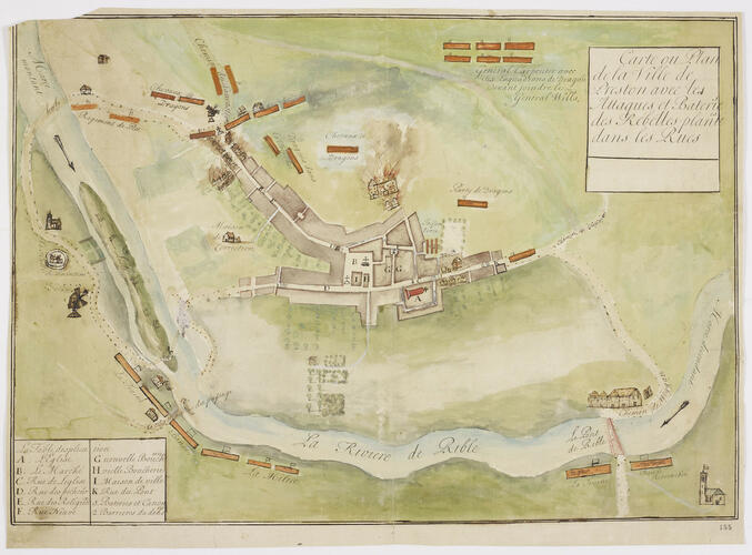
A map of the Battle of Preston, fought between 9 and 14 November 1715 between British forces, commanded by Major-General Charles (later, Sir Charles) Wills (1666-1741) and Lieutenant-General George Carpenter (1657-1732), and the Jacobite Rebels, commanded by Brigadier William Mackintosh, Laird of Borlum (1658-1743), William Maxwell, 5th Earl of Nithsdale (1676-1744), James Radclyffe, 3rd Earl of Derwentwater (1689-1716), and the Jacobite General, Thomas Forster (1683-1738), resulting in victory for the government forces. Jacobite Rising (1715). Oriented with north to top.
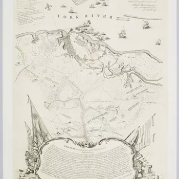
The very tentative attribution of this map to the French Hugenot journalist and military historian Abel Boyer is based only on the use of the French language and its similarity in detail to Boyer's printed map at RCIN 726093. Boyer was born at Castres (upper Languedoc), and came to England in 1689, having apparently seen service in the Dutch army and having been educated, amongst other subjects, in mathematics and fortification. He had in 1695 published A geographical and Historical Description of those parts of Europe which are the Seat of War and in 1699 published the Royal Dictionary which made his name. This was followed by several works including, in 1701, The Draughts of the most Remarkable Fortified Towns of Europe. In 1704 he seems to have become an intelligence agent for the Secretary of State for the northern department, Robert Harley. Boyer became a firm supporter of the Hanoverian succession and this was reflected in many of his publications, including the map of the Battle of Preston at RCIN 726093.
This map shows the buildings of Preston as brown blocks. Some of the places and streets named in the key can be recognised today. For example, ‘L'Eglise’ refers to St John's Minster, ‘Le Marché’ is the Market Square, ‘Rue de Leglise’ is Church Street. ‘Rue des Pecheurs’ is Fishergate, ‘Rue des Religieux’ is Friargate. The ‘Chemin de Cliterow’ is now the B6243 to Clitheroe, and the place where the river was crossed by boat, ‘le Batteau du passage’ is crossed by the A59, the Liverpool Road.
The elongated island on which gambol some rabbits, shown north-west of the ferry, may have been a now long eroded sand or gravel bank. The watercolour has been washed on without finesse but combines with the crude cartography and bright colours of the burning houses to give a sense of immediacy which would be lacking from a more polished effort.
The houses were razed by order of Wills who had hoped that the spreading flames would reach the positions of the Jacobites who had barricaded themselves in the main streets, shown to good effect in this map. The battle was won only after Wills's troops, were reinforced by six squadrons under the command of General Carpenter, shown here to the top right, or north-east, of the map.
Additional text: [bottom left, in rectangular panel, a key, A-I, K, to roads and buildings in the town. Another key, 1-2, locates the positions of batteries and barriers:] La Table desplication.
For further reading, see:
G.C. Gibbs, ‘Boyer, Abel (1667?–1729)’, Oxford Dictionary of National Biography, 2004; online edn, Jan 2008.
S. Handley, ‘Wills, Sir Charles (bap.1666, d. 1741)’, Oxford Dictionary of National Biography, 2004.
H.M. Stephens, ‘Carpenter, George, first Baron Carpenter of Killaghy (1657–1732)’, Oxford Dictionary of National Biography, 2004; online edn, May 2008.
E. Lord, The Stuarts' Secret Army: English Jacobites 1689-1752, Harlow, 2004, p. 83.
Condition: one fold line; piece cut off, top left; two old tears repaired with paper strips. Verso: a large amount of surface dirt.Provenance
Probably from the collection of military and naval maps and prints formed by Prince William Augustus, Duke of Cumberland (1721-65), third son of George II; subsequently acquired by George III (1738-1820)
-
Creator(s)
Acquirer(s)
-
Medium and techniques
Pencil, pen, ink and watercolour on paper
Measurements
Scale: not stated. Not to scale. (scale)
46.7 x 67.6 cm (image)
46.1 x 67.0 cm (neatline)
49.5 x 68.6 cm (sheet) (whole object)
Markings
watermark: Fleur-de-lys in shield, crown above, a ‘4’ suspending the letters LVG below; countermark: IHS [a cross on the H] I VILLEDARY
annotation: Old heading: Preston 13 Nov.r 1715. Other annotations: (Recto) none. (Verso) [top centre, black pencil, cropped:] 1715; [bottom right, black pencil, cropped and illegible]; [bottom, right of centre, red pencil:] 6/2; [bottom, right of centre, black pencil:] VII/[?2].
Category
Alternative title(s)
Carte ou Plan / de la Ville de / Preston avec les / Attaques et Bateries / des Rebelles planteés / dans les Rues
Preston Plan dessiné de la Ville de Preston avec les Attaques et Batteries des Rebelles plantées dans les Rues le 13 Nov.re 1715.


