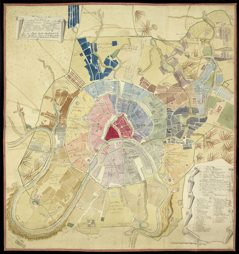
Plan de la Capital Ville de Moscou… c. 1789-1812
Pen and ink with watercolour | 97.0 x 89.0 cm (whole object) | RCIN 710620

Russian School
Plan de la Capital Ville de Moscou? c. 1789-1812
-
A manuscript map of Moscow showing the city’s 20 quarters or districts, highlighted in different watercolour washes. The title, locations and key are in Russian Cyrillic script, with French translations written above, presumably added at a later date. The key lists the city’s ramparts and the monasteries, divided into their locations by quarter. Scale approx. 1:8,400.
Moscow was built at the confluence of the rivers Moskva and Neglinnaia during the twelfth century, and the concentric development of the city from the walls of the Kremlin and Kitai Gorod (the area adjacent to the Kremlin), the Belyi Gorod or ‘White City’, and the Zemlianoi Gorod or ‘Earthen City’ to the outer wall known as the Kamer College can be clearly seen. From 1775, attempts were made by Empress Catherine II to improve the spatial planning and architecture of Moscow, in an effort to turn it into a more ‘enlightened’ city at the heart of her empire, following the example of classicism used in St Petersburg. It seems likely that this map derives from the 1789 plan by Ivan Marchenkov, itself a derivation of the plan created in 1775. The tree-lined Boulevard Ring is clearly visible, replacing the fortified walls of the Belyi Gorod. In 1812, during the course of the Napoleonic Wars, much of Moscow was destroyed by fire when the Russians abandoned the city as Napoleon marched upon it. A plan to rebuild Moscow was finalised in 1817.
There is a note under the title of the map, in French, stating that the plan was presented by de Caverine, First Master of Police of Moscow, to Prince William Frederick of Gloucester (1776–1834), nephew of George III and, from 1805, 2nd Duke of Gloucester and Edinburgh. Prince William Frederick had entered the army at the age of 13 and progressed rapidly, becoming a field marshal in 1816. It is not clear why de Caverine presented him with this map; however, Prince William Frederick seems to have had an interest in Russia and owned a book describing the uniforms and military equipment of Catherine the Great’s army (see RCIN 1082273).
Text adapted from Russia, Royalty & the Romanovs, London, 2018Provenance
Presented by the First Master of Police in Moscow, de Caverine, to Prince Frederick of Gloucester
-
Creator(s)
(cartographer)Acquirer(s)
-
Medium and techniques
Pen and ink with watercolour
Measurements
97.0 x 89.0 cm (whole object)
Category
Object type(s)
Alternative title(s)
Plan de la Capital Ville de Moscow...


